1 Tiger Lily Lane
Harding Township, NJ
An ecological gem, preserved
from deer and invasive species
Page update: January 17, 2024 (Trail Map)

Page update: January 17, 2024 (Trail Map)
 Crayfish caught at the CMA
") Butterfly Weed (Aclepias tuberosa)
Butterfly Weed (Aclepias tuberosa)

 flying squirrels in a birdhouse
 Crayfish caught at the CMAButterfly Weed (Aclepias tuberosa)
You’re invited to explore our Conservation Management Area (CMA) a wooded 73-acre natural area in Harding Township. Its 3.5 miles of boardwalk and mulched trails are open to the public for walking, hiking, and nature study. GSWA has many scheduled events at the CMA throughout the year, including family hikes, natural history explorations, dog walks, and moonlight walks to name a few, but you can enjoy the CMA anytime at your own at your convenience.
The CMA has two trailheads on Tiger Lily Lane in Morristown, NJ. The main trail entrance is located at the end of the cul-de-sac. The second entrance is found mid-way down Tiger Lily Lane. Both areas are connected via the Yellow Trail. Visit the “Trail Map” tab to view or download the trailhead map.
Wear appropriate footwear, as trails can be wet, muddy, and slippery. Stay on the trails for your safety. Dogs on leash are welcome. Trails are open from dawn to dusk, except as noted during hunting season.
How you can help
If you would like to visit the CMA with a group and receive a natural history tour or program, please contact Hazel England, Director of Education and Outreach and Land Steward at hazele@greatswamp.org.
Herd reduction through hunting is allowed on the property with written permission. Each year from mid-September to late-February, trails are open but there may be bow hunting, so proceed with caution. Late November to mid-February is shotgun season, and the trails are closed Monday-Friday, from dusk to noon. Trails are typically closed for the entire first week of December for firearms season. See updated information for the annual dates (hunting info).
NATIONAL LAND TRUST DESIGNATION
GSWA is one of only 8 organizations in New Jersey to Receive the Prestigious Accreditation Seal
The National Land Trust Accreditation Committee announced in August, 2017, that GSWA has been formally designated as an accredited land trust, joining an elite group of only eight land trusts in New Jersey, and part of a network of 389 nationally recognized organizations. This is the culmination of years of work to protect, preserve and promote New Jersey’s open spaces, and this prestigious accreditation will serve as a key anchor for us as we look to provide stronger and broader involvement in land conservation.
Over recent years we have developed and implemented a series of initiatives to serve New Jersey as the premiere land conservation and advocate in the Passaic River region, providing environmental education to community groups, teachers, and students, serving as a needed advocate and defender of New Jersey’s precious natural resources, and promoting an understanding of the importance of protecting our drinking water and preserving the natural beauty of our environment. In addition to the National Land Trust accreditation, last year we expanded our mission to advocate on behalf of the entire Passaic River and became the formal river affiliate to the nationally based Waterkeeper Alliance.
“We are all very proud to receive formal accreditation from the National Land Trust Commission. The Trust’s seal of approval is extremely valuable to us and to our specific plans for greater activism in the future. Like many in our country right now, we are inspired and invested in taking a more active approach when it comes to the debates regarding our planet. This national recognition places GSWA in a select group, and underscores our strong commitment to permanent land conservation, protecting New Jersey’s ecological havens, and using facts, science, and education when it comes to creating environmental policy.” -Hazel England, GSWA Director of Education, Outreach, and Land Stewardship.
It was through a series of land acquisitions over the course of many years that led to GSWA’s ownership of 73 acres of undeveloped land. This was the catalyst to applying for the National Land Trust designation. This plot of land, known as the Conservation Management Area (CMA) is fully protected and stewarded by our organization.
“It’s a great example our preservation efforts. The CMA is an ecological gem; and our goal is for this area to be restored to its natural state, free of deer and invasive species, and home to several state and federally designated threatened species. It’s an excellent spot for families, schools, community groups, and individuals to hike the trails and learn more about what we do through our interpretive signs.” -Hazel England
Through this accreditation, we will continue to focus on securing additional environmentally sensitive properties in the area. If you’re interested in working with us to preserve land in the region, contact Hazel at hazele@greatswamp.org, or call 973-538-3500
The Land Trust Accreditation Commission is an independent program of the Land Trust Alliance, a national land conservation organization working to save the places people need and love by strengthening land conservation across America. The process by which an organization achieves this accreditation is a rigorous one. Applicants are required to provide extensive documentation and undergo a comprehensive review, providing proof of sound finances, ethical conduct, responsible governance and lasting stewardship of the lands they protect. Once achieved, accreditation ensures permanence in the conservation of open lands.
“It’s exciting to recognize Great Swamp Watershed Association with this distinction,” said Tammara Van Ryn, Executive Director of the Commission. “Accredited land trusts are united behind strong ethical standards ensuring the places people love will be conserved forever.”
Beginning in 1996, we gradually acquired 73 acres of property in Harding Township. Managed as a single unit we call the Conservation Management Area (CMA), the site contains critical wetlands, freshwater marsh, vernal pools, forested areas, and the Silver Brook (a tributary to the Great Brook and Passaic River), and is home to several state and federally designated threatened species, including wood turtle and barred owl.
The property is traversed by a network of trails, with more than three miles of boardwalk and mulched paths winding through the forest and marsh habitat, and the trail system is still expanding! Trails are open to the public, and we encourage community groups and schools to use it as an environmental teaching tool. Dogs on leash are permitted, we just ask pet owners to pick up after their pets and properly dispose of their droppings. See our Trail Map tab for the trailhead maps…Happy Hiking!
The long term stewardship goal for the CMA is to restore the property to a diverse and ecologically functioning floodplain forest. Our stewardship focuses on ecological restoration and enhancements of existing habitats, and to date has included extensive control of invasive plant species, enhancement of vernal pool habitat used by breeding amphibians, stream bank stabilization and replenishment, and improvement of habitat lost as a result of degradation by invasive species and deer browsing. Almost 30 acres of the property are fenced against deer browse, allowing for the forest understory to regenerate, aided by our extensive native plantings.
Our secondary management objective is to optimize the site as a location for environmental education. We hope that schools, community groups, and individuals will all take advantage of our interpretive signs and information.
The below map shows the two trail entrances of our Conservation Management Area in Harding Township, NJ. The first trail entrance is at the end of the cul-de-sac on Tiger Lily Lane. The second entrance is found mid-way down Tiger Lily Lane. Both areas are connected via the Yellow Trail. Enjoy your hike!

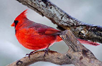
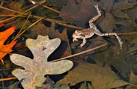
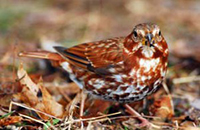
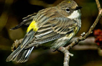
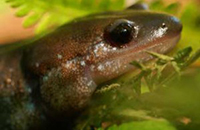
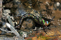
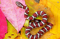
The CMA is home to many exceptional plant and animal species, including several state and federally designated threatened species like the barred owl and swamp pink.
You can view a list of plant and animal sightings at the CMA here.
Want to know what you might see during a visit to the CMA? Use our month by month guide, created by volunteer and naturalist Blaine Rothauser.
Have a sighting to report? Email Val Thorpe, vthorpe@greatswamp.org, to have it added to our list.
The CMA is used by many groups, including the Northern New Jersey Cachers! Geocaching is an outdoor recreational activity where players use their GPS device to find hidden caches (containers that typically hold a logbook to sign and mark your find). These caches will be hidden throughout the area, and you will find them based on coordinates (longitude and latitude) as you explore the beautiful trails of GSWA’s Conservation Management Area.
UPDATE 12/4/21: There are 7 brand new caches going live at the CMA in addition to the other geocaches hidden at this location.
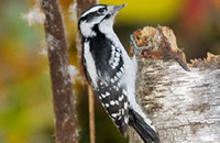
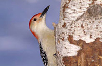
The CMA offers ample birding opportunities from familiar year-round residents to water birds to migrating Spring warblers.

Submit your eBird checklist and share it with us – let us know what you see at the CMA!
We are on eBird as GreatSwampCMA. Check us out!
Notifications