By Hazel England, GSWA Director of Education and Outreach, Land Steward
Our long-awaited Conservation Management Area (CMA) restoration finally began in the last week of September at our 73-acre forested wetland along Tiger Lily Lane, and along the adjoining lands belonging to Harding Land Trust. This wetland and stream restoration project has been over ten years in the making! We have had to variously wait for:
- money to be in the budget of the US Department of Agriculture Natural Resources Conservation Service to pay their portion of the work;
- DEP permitting to allow the work to go ahead without breaking any wetland rules;
- and workable windows of time throughout the year that are controlled by the presence of endangered and threatened species on the property.
Finally, the stars aligned and the weather was dry for the six weeks leading up to our working target window of October this year, and the work could begin!
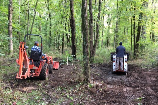
Our contractor, Indigenous Ingenuities of Doylestown, PA, arrived with their mini-excavators and began the first of the three practices that will be undertaken towards restoring water flow to historic routes at the site. They deepened and sculpted our wetland areas to create shallow depressions, 18-24” deep, known as vernal pools. The soil they removed was used to fill the ditches that have been dug into the property in the past to drain the land for agriculture. By plugging these mosquito ditches with soil, they allow water falling as precipitation to stay for longer on the site.
The very next day after excavation at the cul-de-sac area was completed, we received 2” of rain, and got to see a wetland as it is supposed to be- WET! The water now stays around for longer, and the original hydrology at the site (the connectedness of water moving along the surface and through the soil) has been returned to its historic state. This may mean our trail system is temporarily wetter in parts, and we will need to create solutions to keep hikers’ feet relatively dry as they walk our trail system, but we are excited to share the changes.
Next our contractors will move onto adding woody debris, pinned into the banks of the Silver brook, which flows through the site. This bank stabilization will allow the stream to begin to flow in a more curvy fashion, as first one bank, and then the other is “hardened” and protected from erosion. The streambanks were historically straightened, meaning that water flows through the site more rapidly than it should (think a fire hose carrying high velocity water- and carrying sediments and eroding the banks with the increased velocity).
We still have a few days of work remaining, but by next spring we will be able to see the changes we have implemented take shape. The long-term goal is for improved water holding at the CMA, and gradually improving water quality.
Come visit to see the changes – but in the short-term, bring your wellies just in case!